
John Fuller of Newton
The Second Division of the Fuller Farm – 1730
The second division of the original Fuller Farm area was the 1730 Agreement between the land owners within the farm area at that time, which included several of John’s sons. This agreement was the basis of the official opening of a highway through the farm area adopted by the town of Newton in 1751.
Francis Jackson[1] dedicated a section in his book to the location of Early Highways in Newton starting on page 37. At the bottom of page 42: “1751. A new way laid out through the ‘Fuller farm,’ beginning at the house of Josiah Fuller, at a rock in said Fuller’s fence, on the south side of the way, thence to Cornet John Fuller’s land, widow Hannah Fuller, Joshua Fuller, to land of Thomas Fuller, deceased, to Jonathan Fuller and over the brook called Cheese-cake brook, two rods wide, from said Josiah Fuller’s easterly to said brook. [Signed by the land holders.]”
Jackson’s reference to ‘signed by the land holders’ refers to the 1730 agreement as “Extracts from Newton Records.[2]
1730, May 13 – Agreement transcribed below
1730 Agreement [3]
Fuller, Jeremiah Fuller John Fuller Jonathan Fuller Isaac Fuller Jonathan Fuller Jun[io]r Thomas Fuller Isaac Fuller Jun[io]r Caleb Fuller Joshua Fuller all of Newton in the County of Middellsex in the [sic] of the Massachusets bay in New England and Joshua Fuller of Cambridge in the County afores[ai]d and do all and every one of us agree and concent to Lay out an open way two Rods[4] wide, as it is alowed of in the settlement of the Farm caled the Fuller Farm, for the use of and convenience of ye proprietors of said Farm: lying as it is now Laid out from the division of said farm down to the town way, at Solomon Park’s line, marked on a walnut tree & a heap of stones in Jonathan Fuller’s land: and then a walnut tree, and then a white oak, and then a peach tree, on land of Joseph Fuller, and then a white oak tree, on ye land of Jeremiah Fuller, and then to a white oak and then to a gray oak and then to a walnut tree and then over ye dam at ye upper end of the wet meadow, and then to a Rock, on ye land of Jonathan Fuller and then to ye Town way for us; And also agreed to have liberty of passing through gates or bars from one proprietor’s way to the other where the way is now trod. And we do oblige our selves and our heirs to mend and maintain the said way for Ever from the corner of the line between John Fuller and Jonathan Fuller and down to the town way at Solomon Park’s line.[5][6]
“In witness whereof, we set our hands and seals, this thirteenth day of May, Anno Domini one thousand and seven hundred and thirty in the third year of the reign of our sovereign Lord George Second, of Great Britain, King, &c.[7]
| Signed Sealed in presence of us Elizabeth + Mirick (her mark) Mindwell Fuller Priscilla + Dike (her mark) |
Joseph Fuller Joshua Fuller Jeremiah Fuller John Fuller Jonathan Fuller Jonathan Fuller Jr. Isaac Fuller Isaac Fuller Jr. Thomas Fuller Caleb Fuller |
1751 Town Record-Public Road through the FullerFarm
The following is an extract from the Feb 4, 1750/1 Town Meeting Records which formally sets up a new public road through the Fuller Farm:[8]
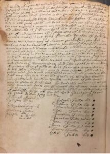
“Newton February 4th, 1750[/51]”
Newton Town Meetings 1715-1758, p 243
“We the Subscribers Selectmen of the Town of Newton have the desire and Request of A Number of the Inhabitants of Said Newton Laid out an open Way for the use of Said Town (Said Way being through the Land Called Fuller Farm) we begin near the House of Josiah Fuller at a Rock in the said Josiah Fuller Fence which is on the South side of said Way from said Rock to A stake and stone by a White oak Stump from thence to A White oak marked, from thence to another White oak marked, from thence to A stake and stone at the Corner of John Fullers Land, from thence to a stake and stones of the Land of
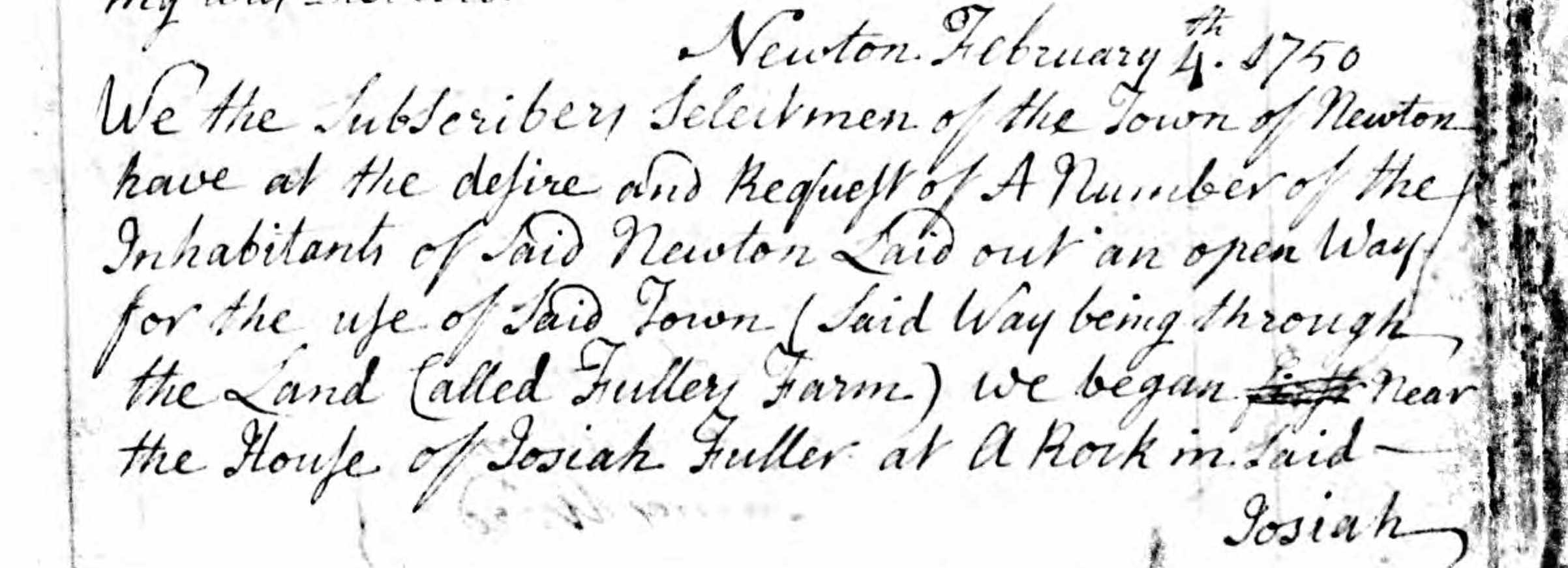
Newton Town Meetings 1715-58 p244
the Widdow Hannah Fuller and Ensign Joshua Fuller from thence to a stake and stones, from thence to a Large Blew Stone in Ens[ig]n Fullers Wall, from thence to a stake and stones by said Ens[ig]n Fullers Wall, from thence to Rods West from the appletree which is at the Corner of the Casway, from thence to a Rock and heap of stones near the Southerly end of the Casway, from thence to a stake and Stones at the Corner of the Land Belonging to the Heirs of Thomas Fuller Deceased, and from thence as the wall now stands toll it comes to the Land of Jonathan Fuller the third, from thence to a Rock in said Jonathan Fullers Fence & from thence as the Fence now stands till it comes over the Brook Called Cheasecake Brook, and from said Brook the Bound[ary] is the Fence on the northerly side till it comes to the Town Way at the Brow of the Hill the above said Way is Two Rods wide from Josiah Fuller to the Easterly side of the abovesaid Brook and from thence to be one Rod Wide”
“Henry Gibbs )
Caleb Henrick ) Selectmen
Isaac Jackson )
James Ward )
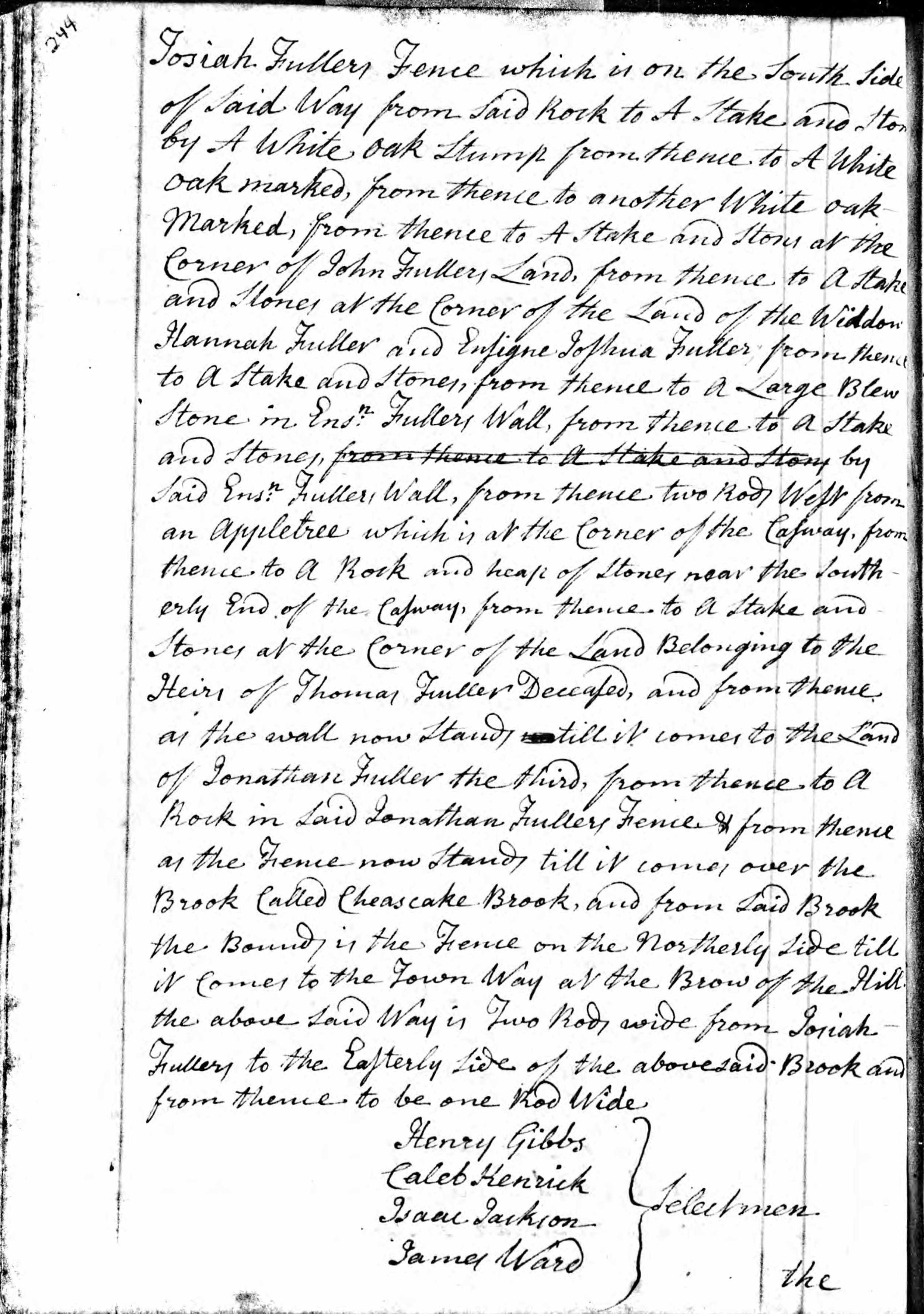
The aforesaid Way was laid out with the consent and the full satisfaction of us
Newton Town Meetings 1715-58, p245
the Subscribers who are owners of the Land adjoining on both sides of the said Way and have received full satisfaction for said Way. In Witness whereof we have hereunto set our hands the Day and Year first above written.
Jonathan Fuller
Joshua Fuller
Josiah Fuller
Jonathan Fuller third
John Fuller
Jonas Priest
Jonathan Fuller”
___________________________________________________________________________________
1. Francis Jackson, A History of the Early Settlement of Newton, county of Middlesex, From 1639 to 1800, with a Genealogical Register of its Inhabitants Prior to 1800. By Francis Jackson of Boston, a Native of Newton. Boston: Printed by Stacy and Richardson, 1854.
2. Jackson [note 1] bottom of page 45. has abbreviated the 1730 agreement:
“The undersigned do all and every one of us agree and consent to lay out an open highway, two rods wide, as it is allowed of in the settlement of the farm called ‘Fuller’s farm,’ for the use of and convenience of the proprietors of said farm, down to the town way, at Solomon Park’s line, marked on a walnut tree and heap of stones in Jonathan Fuller’s land: and then a walnut tree, and then a white oak tree, and then a peach tree, on land of Joseph Fuller, and then a white oak tree, on land of Jeremiah Fuller, and then to a white oak tree, and then to a gray oak tree, and then to a walnut tree, and then over the dam, at the upper end of the wet meadow, and then to a rock, on the land of Jonathan Fuller, and then to the town way, for us. And also agreed to have liberty of passing through gates or bars, from one proprietor’s way to the other, where the way is now trod. And we do oblige ourselves, and our heirs, to mend and maintain the said way forever, from the corner of the line between John Fuller, and down to the town way at Solomon Park’s line.
In witness whereof, we set our hands and seals, this thirteenth day of May, Anno Domini in the third year of the reign of our sovereign Lord George Second, of Great Britain, King, &c.
| (signed.) In presence of us: Elizabeth + Mirick, (her mark). Mindwell Fuller, Priscilla + Dike. (her mark). |
Joseph Fuller Joshua Fuller Jeremiah Fuller John Fuller Jonathan Fuller Jonathan Fuller Jr. Isaac Fuller Isaac Fuller Jr. Thomas Fuller Caleb Fuller |
Division of the Fuller farm, 788 acres. The town accepted this way 1751.”
3. This 1730 agreement was taken from page 12 of the original Newton ‘Town Book’. The repository is the Newton Archives, 330 Homer Street, Newton Centre, Newton, MA 02459, USA
4. One rod equaled 16.5 feet (5.03 meters) in the day and therefore this highway would have been 33 feet (10.06 meters) wide, which even in today’s standards is a very wide road; per Wikipedia ‘United States Land Measurements’.
5. This agreement sets a highway through the Fuller Farm for the exclusive use of the residence of the farmsteads within the land area of the Fuller Farm. Also it is likely the foundation of the 1751 entry in the Town Meeting Records where the Town accepted a new highway within and through the Fuller Farm which was open to the public as a Town Road as shown on the 1700 map of Newton.
6. This agreement was signed by ten descendants of John Fuller Sr. as well as three witnesses, all likely affected by the terms of this private agreement by the land owners as of 1730. In his Will of 1697/8, John Sr. gave each of his five sons a farmstead of about 200 acres and the Will stipulated that “…..and further my will is that my abovesaid sons shall not allinate [alienate – to transfer ownership] the above given and granted lands unto any stranger until first the next relation of the above said Fullers have the offer of it…….”. This may have led the family to treat the entire farm as a private family area longer than usual if each one had to sell to another Fuller family member before considering a ‘stranger’, which was John’s intent. We know the location of the farmsteads of each of the sons. When this agreement was signed in 1730, two of the sons had died, however from their Wills we can determine the names of the owners of those farmsteads in 1730. In his Will, John Sr. distributed his land to each of his sons:
1. John Jr. died in 1720/21 and in his Will left a farm, to his sons John III (79 Acres) and Isaac (52 Acres) with the house to be shared ½ each. In addition he gave to his sons Jonathan and Caleb, each 34.5 Acres and ½ of his original farmstead of 1682 (shown on the Map of 1700).
2. Jonathan died 1722 and in his Will left his farm to his nephew, Captain Jonathan Fuller, except his wife, Mindwell, was to live in one end of the house for as long as she lived (in fact she lived 36 years after her husband and died in 1758).
3. Cap. Joseph died in 1739/40 and was alive in 1730 but may have lived on the 23 acres gifted by his father-in-law, but likely owned lands within the original Fuller Farm area. His Will gave his three sons, Lieut. Joseph (b. 1685; m.1719), Capt. Jonathan (b. 1686; m. 1717) and Isaac (b. 1698; m. 1722) all his land clear from any encumbrances.
4. Joshua died 1752 and was alive in 1730, however had no sons after three marriages and may have sold his land to his brothers. His Will of 1752 showed an estate of 2200 pounds, but no land.
5. Jeremiah was born in 1658 and died in 1743, so was only 62 in 1730. His son Thomas was born in 1701 and likely received his inheritance at the time of his marriage in 1728, which was formalized in Jeremiah’s Will of 1743; “…where he lives E of my farm….”. East of Jeremiah might mean that Thomas may have taken over John Sr.’s farmstead in 1728. Thomas is mentioned in the 1751 Town Record document as being deceased as he died in 1748.
7. George II reign was from June 11, 1727 until his death in 1760 per Wikipedia ‘George II of Great Britain’; so the date of 13 May 1730 fits within that time period.
8. A copy of the original town meeting book, Newton Town Meetings 1715-1758, Book 1, 312 pages, Original data: Town and City Clerks of Massachusetts com. Massachusetts, Town and Vital Records, 1620-1988 [database on-line]. Provo, UT, USA: Ancestry.com Operations, Inc., 2011. Partial page 243, page 244 and partial page 245.